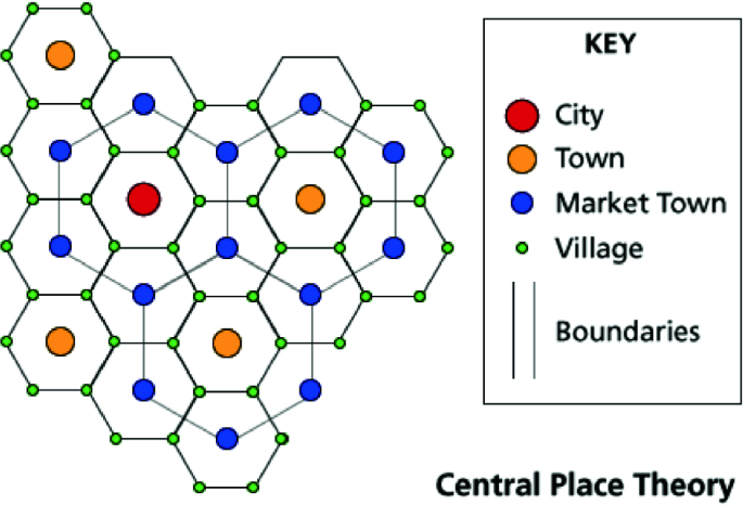
Christaller's Central Place Theory
-Bigger cities provide more services and goods, so there are less and they are farther apart.
-Smaller towns offer fewer services and goods, so they're more common and closer together.
-Assumes that all areas have an isotropic (all flat), homogeneous, limitless surface, and an evenly distributed population.
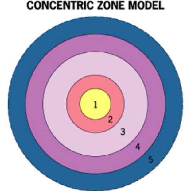
Burgess Concentric Zone Model
-Based in Chicago
-Relates to bid-rent theory
1. CBD- Greatest land value
2. Zone of Transition- mixed use zone containing industry, factories, light manufacturing, etc.
•Tends to be a low income area with multi family living spaces
3. Working Class Residential- Near factories for work access
•Closely spaced single family living spaces
4. Middle Class Residential- Better residences and homes
•More single family homes and apartments but the population density is lower than zone 3.
5. High Class Residential/Commuter- More expensive, single family, and detached housing
•More space and lowest population density
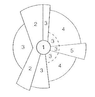
Hoyt Sector Model
-Assumes that there are zones of growth from the CBD based on transportation routes, there is still a strop CBD, similar socioeconomic groups clumped together in a sector, and lower socioeconomic housing
1. CBD
2. Transportation Route
3. Low Income sector- near industry and transportation
4. Middle Income Sector- Away from bad stuff from industry and transportation
5. Upper Income Sector- Along boulevard, shops, white collar services
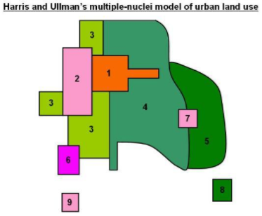
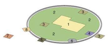
Harris/Ullman Multiple Nuclei Model
-Assumes that growth occurred independently around several major nodes, the CBD is not the most important part since there are more nuclei, and exurbs are taken into account.
1. CBD
2. Wholesale/Light Manufacturing
3. Low-Class Residential
4. Medium-Class Residential
5. High-Class Residential
6. Heavy Manufacturing
7. Outlying Business District
8. Residential Suburb
9. Industrial Suburb
Galactic City/Peripheral Model
-The city is surrounded by a beltway that goes with the development of sprawl
-Low density development of buildings
-Edge cities exist on the outside which are more built up suburbs
-Shows decentralization
1. Central City
2. Suburban Residential Area
3. Shopping Mall
4. Industrial District
5. Office Park
6. Service Center
7. Airport Complex
8. Combined Employment and Shopping Center
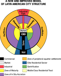
Griffin/Ford Latin American City Model
-Has sectors and rings
-Wealthier people live near CBD and spine
-CBD contains historical and modern elements like churches (catholic) or govt buildings
-Elite rich people along spine
-Extremely poor live on disamenities
1. Zone of Maturity- older people and middle class live here, along CBD
2. Zone of Situ Accretion- Modest housing with a mix of deterioration and gentrification
3. Zone of Peripheral- Squatter settlements and disamenity sectors, high poverty, along trains on steep slops and bad infrastructure
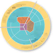
The African City Model
-No longer accurate
-Shows affects of European colonialism
-Mining and manufacturing zones near cheap labor
-High income near high quality infrastructure near CBD’s
1. Colonial CBD- Vertical development gridded for order and control
2. Transitional CBD- Commerce is conducted in curbside stalls, single level stores
3. Informal CBD- Sometimes a periodic market zone, tends to be open air
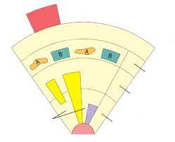
The Southeast Asian City Model
-Based on port, no CBD
-Unlike the other models settlement placement isn’t based on socioeconomic factors since squatter settlements are located next to suburbs
-Agricultural and industrial zones are on the outside
-Not accurate since there are CBD’s in SE Asia
-Alien commercial zone is dominated by Chinese merchants whose residences are attached to their places of business
-The western commercial zone is dominated mostly by Britain and other European countries