Space
geometric surface of the Earth
Activity space
he area wherein activity occurs on a daily basis
Place
an area of bounded space of some human importance
Regions
a type of place, and there are other categories of places, such as urban places, places of work, resource locations, and transportation nodes
Attributes of a place change over time
sequent occupancy
the succession of groups and cultural influences throughout a place’s history
Map scale
ratio of distance on a map to distance in the real world in absolute terms
Relative scale, or scale of analysis
level of aggregation, or in other words, the level at which you group things together for examination.
Scales can range from local to city and state, from regional to national to continental, or to the international and global scales
Formal regions
areas of bounded space that possess some homogeneous characteristic or uniformity
Culture regions
tend to have fuzzy borders
Political regions
boundaries are finite and well-defined
Environmental region
are transitional and measurable
Functional regions or nodal regions
are areas that have a central place, or node, that is a focus or point of origin that expresses some practical purpose
Market areas
intervening opportunity
an attraction at a shorter distance that takes precedence over an attraction that is farther away.
Vernacular regions
based upon the perception or collective mental map of the region’s residents
equator
0° latitude. The North and South Poles are 90° latitude
Site and Situation are locational concepts that work together
Site refers to the physical characteristics of a place
Situation refers to the place’s interrelatedness with other places
Tobler’s law
all places are interrelated, but closer places are more related than farther ones.
Friction of distance
the length of distance that becomes a factor that inhibits the interaction between two points
Human-Environmental Transportation
the effect that humans have on their environment, and vice versa
Central place theory
developed in the 1930s by the German geographer Walter Christaller
city location and the level of urban economic exchange could be analyzed using central places within hexagonal market areas, which overlapped at different scales
CBD (central business district)
the core of the urban landscape, a country’s capital is the core of its political landscape.
Agglomeration
when clustering occurs purposefully around a central point or a economic growth pole
sinous
wavy line pattern
rectilinear township and range
survey system based upon lines of latitude and longitude
Long-lot patterns
narrow frontage along a road or waterway with a very long lot shape behind.
Arithmetic density
most often calculated as the number of things per square unit of distance.
Physiologic density
measures the number of people per square unit of arable land, meaning land that either is actively farmed or has the potential to be
Agricultural density
refers only to the number of farmers per square unit of arable land
Expansion diffusion
originates in a central place and then expands outward in all directions to other locations.
Hierarchical diffusion
originates in a first-order location and then moves down to second-order locations and from each of these to subordinate locations at increasingly local scales
Contagious diffusion
begins at a point of origin and then moves outward to nearby locations, especially those on adjoining transportation lines
stimulus diffusion
pattern is a general or underlying principle that diffuses and then stimulates the creation of new products or ideas
Relocation diffusion
pattern begins at a point of origin and then crosses a significant physical barrier, such as an ocean, a mountain range, or a desert, and then relocates on the other side
spatial analysis
the mathematical analysis of one or more quantitative geographic patterns
Topographic maps
show the contour lines of elevation, as well as the urban and vegetation surface with road, building, river, and other natural landscape features
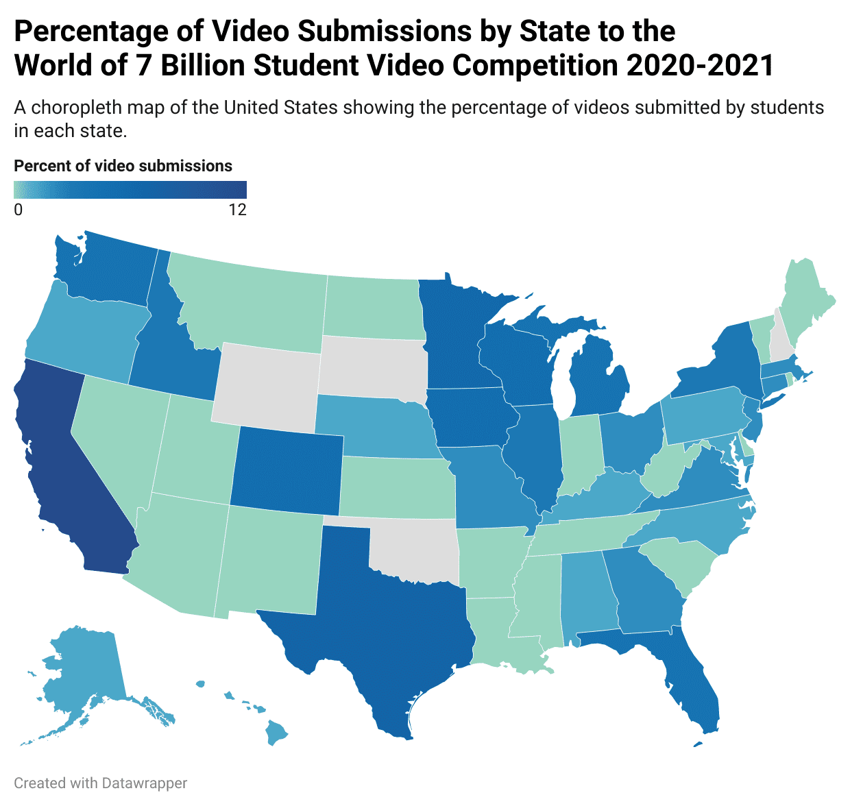
Choropleth maps
a thematic map that expresses the geographic variability of a particular theme using color variations.
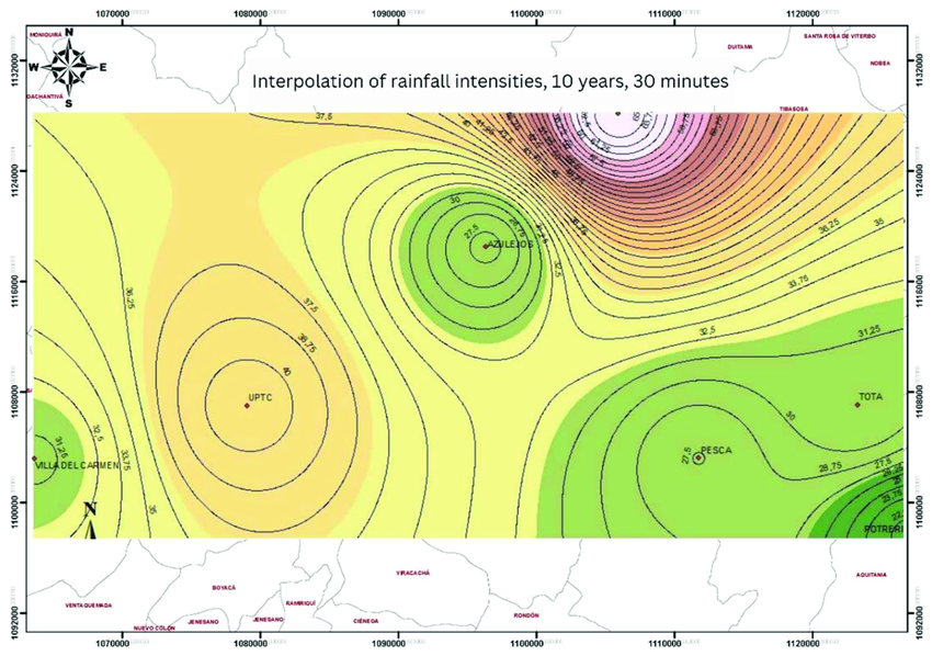
Isoline maps
calculate data values between points across a variable surface.
Dot density maps
use dots to express the volume and density of a particular geographic feature.
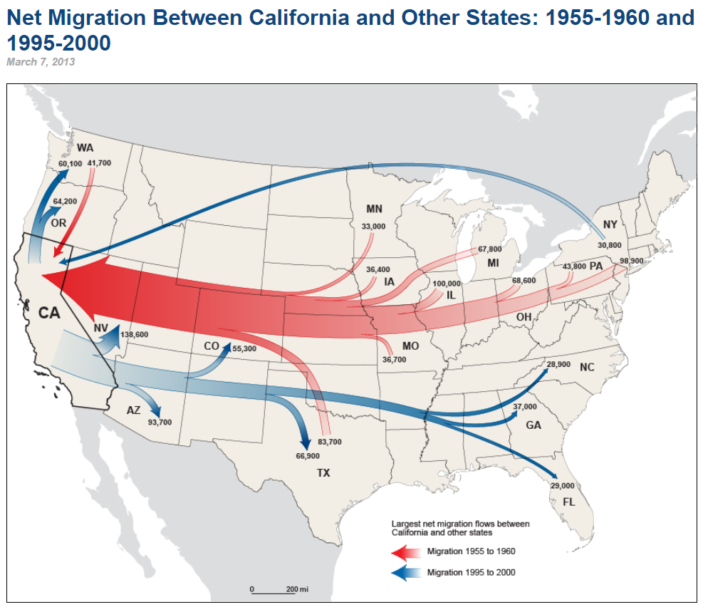
Flow-line maps
use lines of varying thickness to show the direction and volume of a particular geographic movement pattern.
Cartograms
use simplified geometries to represent real-world places.
large-scale map
one with a ratio that is a comparatively large real number
small-scale map
one with a ratio that is a comparatively very small real number
Robinson projection and the Goode’s homolosine projection
balance area and form, sacrificing a bit of both to create a more visually practical representation of the Earth’s surface.
Conformal projections
attempt to maintain the shape of polygons on the map.
distortion of the relative area from one part of the map to the other
Equal-area projections
attempt to maintain the relative spatial science and the areas on the map.
distortion of the actual shape of polygons
Demographic transition models
non-spatial models that use population data to construct a general model of the dynamic growth in national scale populations without reference to space.
gravity model
a mathematical model that is used in a number of different types of spatial analysis
used to calculate transportation flow between two points, determine the area of influence of a city’s businesses, and estimate the flow of migrants to a particular place
Urban models
try to show how different cities have similar spatial relationships and economic or social structures**.**
Spatial models
attempt to show the commonalities in pattern among similar landscapes
oncentric zone model
can be modified to create a graph showing the cost-to-distance relationship in urban real estate prices.
Geographic Information Systems (GIS)
became practical with the onset of the desktop computer in the 1970s.
incorporate one or more data layers in a computer program capable of spatial analysis and mapping.