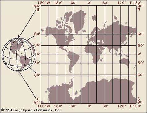
Mercator projection
conformal cylindrical projection
standard map projection
exaggerates areas far from equator
standard projection
preserves shape
conformal
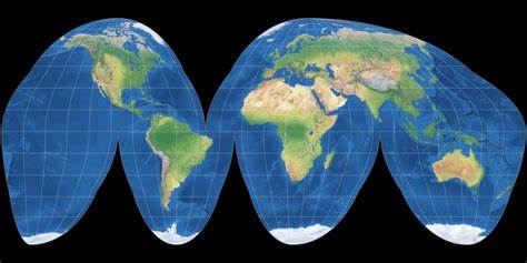
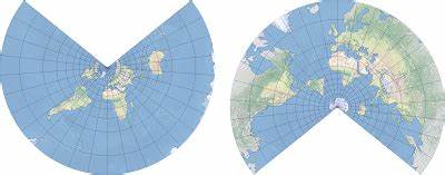
Goode Homolosine projection
equal area projection that is true size/shape of land masses
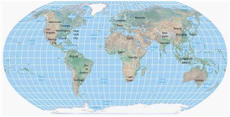
Robinson projection
map projection that shows entire world
distortion in the poles
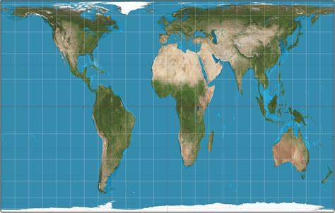
Gall-Peters Projection
equal-area map that corrects distortions in other projections
represents nations in true proportion to one another
accurate
conformal map projection
conformal projection
Conformal projection: A map that preserves angles, making it useful for navigation and meteorology. Distortion increases with distance from the center point.
Reference map
shows informational data that shows boundaries, names, and geographic features.
direction, property lines, political boundaries, and elevation
thematic maps
displays spatial patterns and uses quantitative data to display topics.
absolute direction
exact direction a person is heading
relative direction
direction in relationship to another objects current location
absolute distance
exact distance between 2 places
relative distance
approximate measure of the distance between 2 places
absolute location
exact spot on earths surface by longitude and latitude
relative location
how a place is related to other places
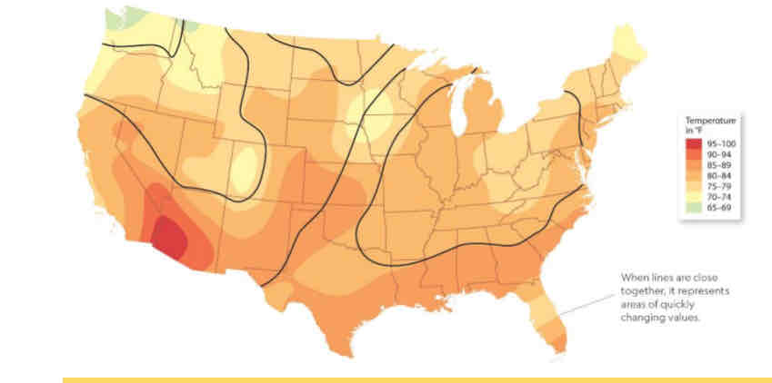
Isoline Map
Lines connect data points of the same value. Isoline maps are used to show particular characteristics of an area.
Thematic map
displays spatial patterns of places uses quantitative data to display specific topics
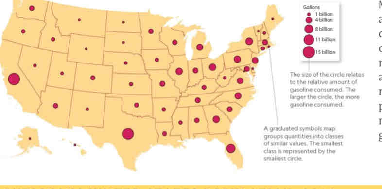
Graduated Symbols Map
Differently sized symbols are used to indicate quantitative data. Bigger circles or icons represent a larger numerical value of a particular attribute
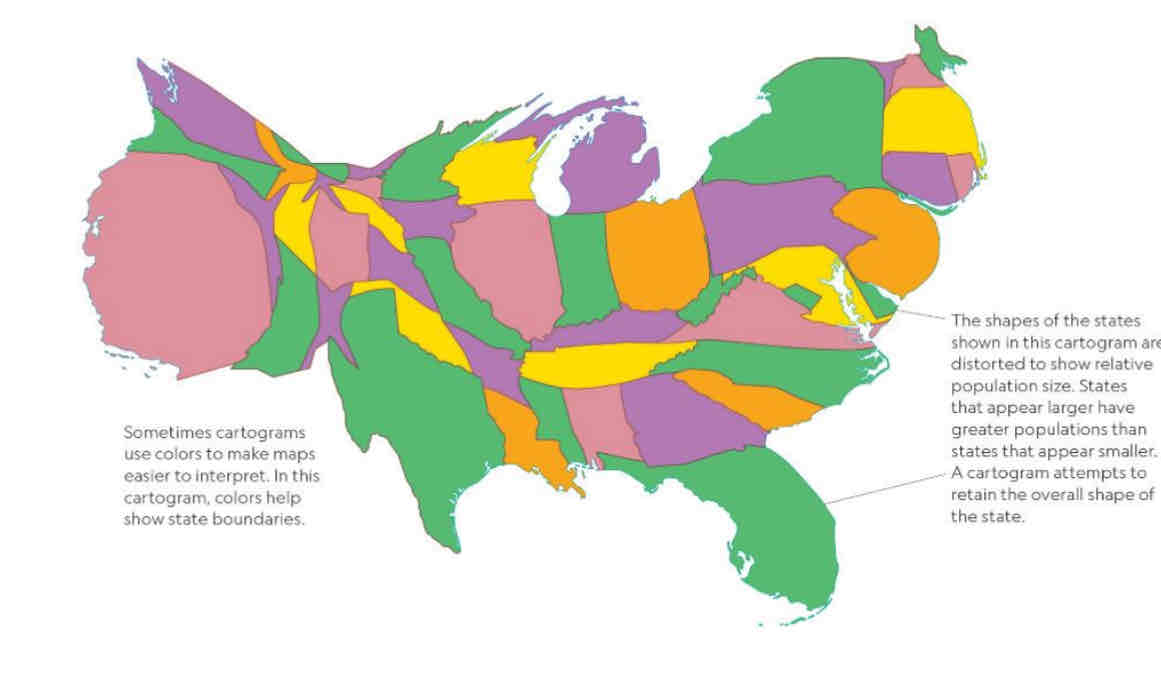
cartogram
Statistical data and geographic location are combined to communicate information at a glance. show the relative size of an area based on a particular attribute, like population or energy consumption.
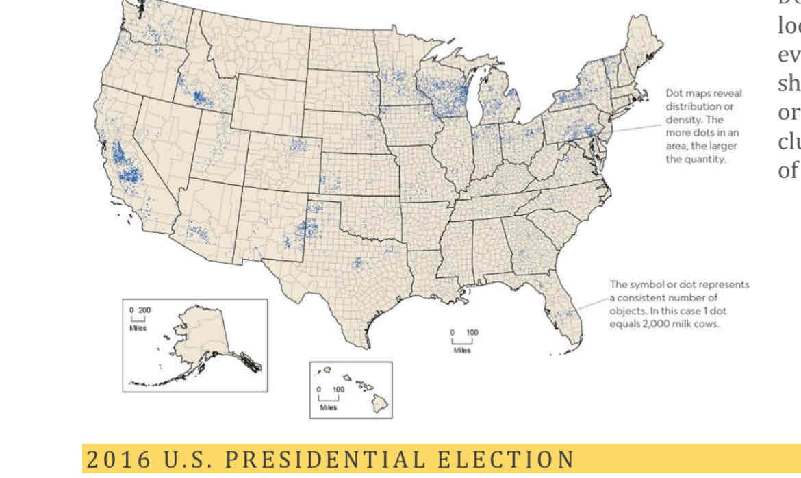
Dot Map
Dots are used to show locations of specific observations or events. are useful for showing statistics like crimes, births, or car accidents.
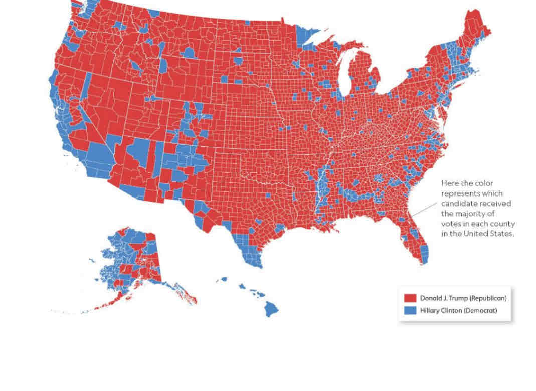
Chloropleth map
This thematic map uses colors or shading to represent categories of data for predetermined geographic areas such as census tracts, counties, states, provinces, or countries
Physical geography
the study of natural processes and the distribution of features in the environment, such as landforms, plants, animals, and climate.
Human geography
the study of the events and processes that have shaped how humans understand, use, and alter Earth.
spatial perspective
where something occurs
Location
the position that a point or object occupies on Earth.
Place
place is a location on Earth that is distinguished by its physical and human characteristics.
sense of place
the emotions attached to an area based on their personal experiences.
site
place’s absolute location, as well as its physical characteristics, such as the landforms, climate, and resources.
situation
refers to a place’s location in relation to other places or its surrounding features. Situation describes a place’s connections to other places, such as transportation routes (like roads, rail lines, and waterways), political associations, and economic and cultural ties.
space
arrangement of things
distributed
how things are arranged in a space
density
number of things—people, animals, or objects—in a specific area.
pattern
how things are arranged in a particular space
flow
The study of the flow of people, goods, and information and the economic, social, political, and cultural effects of these movements on societies is an important aspect of human geography.
environmental determinism
argues that human behavior is largely controlled by the physical environment
fails to take into account the fact that civilizations in other regions, such as North Africa and much of Asia, arose earlier than those in Europe and North America and were more advanced technologically and highly influential culturally for long periods of human history.
possibilism
argues that humans have more agency, or ability to produce a result, than environmental determinism would suggest.
distance decay
describes the effect of distance on interactions. The principle states that the farther away one thing is from another, the less interaction the two things will have.
friction of distance
concept that states that distance requires time, effort, and cost to overcome.
time space compression
It describes the processes causing the relative distance between places to shrink. Modern transportation has greatly reduced travel times, and the internet and other forms of communication have made it easier to communicate with people anywhere on the planet and to send money around the world through online banking transfers.
sustainability
use of Earth’s land and natural resources in ways that ensure they will continue to be available in the future.
scale
area of the world being studied
region
an area of Earth’s surface with certain characteristics that make it distinct from other areas.
formal region
an area that has one or more shared traits. It is also referred to as a uniform region.
functional region
an area organized by its function around a focal point, or the center of an interest or activity
node
focus of the functional region like a downtown city
perceptual (vernacular) region
type of region that reflects people’s feelings and attitudes about a place. A perceptual region, therefore, is defined by people’s perceptions of the area—that is, their subjective understanding of the world as influenced by their culture and experience
the midwest
globalization
the expansion of economic, cultural, and political processes on a worldwide scale.
census
official count of the number of people on a defined area
every ten years
quantitative data
measured in numbers
not subjective
qualitative data
interpretations of data sources such as field observations, media reports, travel narratives, policy documents, personal interviews, landscape analysis, and visuals such as art or photographs.
subjective
cartographer
created maps to help explorers follow the routes of those who came before them and to estimate how long it might take to travel to uncharted lands.
map scale
mathematical relationship between the size of a map and the part of the real world it shows
It allows you to measure absolute distance
small scale map
It covers a large area and shows even fewer details than the medium-scale map.
large scale map
The map scale shows that a half inch on the map represents a quarter mile on Earth’s surface.
remote sensing
collecting info about the earths surface from satellite orbiting earth
used in gis to make thematic maps
geographic information system (GIS)
computer system that collect, analyze , and display geographic data
makes layered maps
global positioning system (GPS)
network of satellites that are useful to determine the location of something on earths surface
toblers law
Everything is related to everything else, but near things are more related than distant things