agglomeration
the spatial grouping of people or activities for mutual benefit; a process involving the clustering or concentrating of people or activities
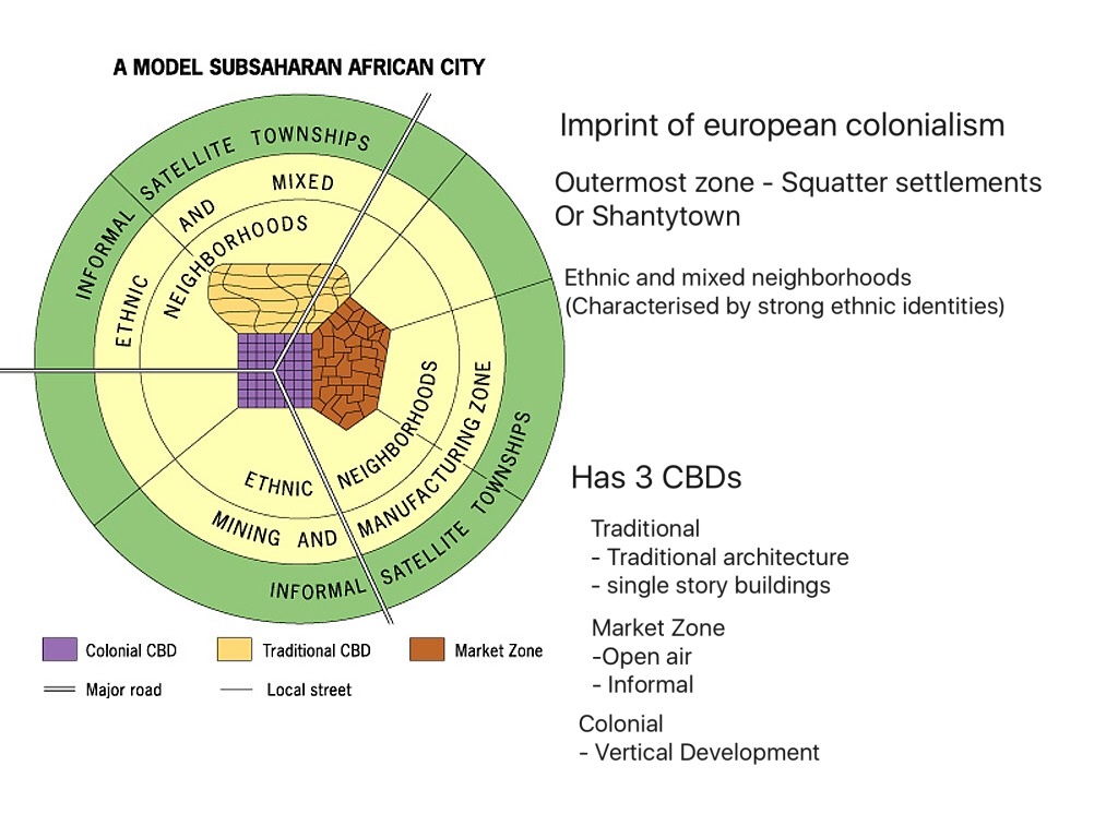
African city model
A model with inner rings housing higher-income people, near business and consumer services, with three CBDs: Colonial, Traditional, and market
creator: Harm deBlij's
African city model pros and cons
Pros:
1. Recognition of African Urban Importance: The de Blij model acknowledges the significance of African cities, which historically have been overlooked in Western discourse and pedagogy. By highlighting African urban areas, it contributes to a more inclusive understanding of global urbanization.
2. Inspiration for Future Urban Planning: As African cities continue to grow rapidly, the de Blij model serves as inspiration for acknowledging their potential and addressing their unique urban challenges. This can inform future urban planning efforts in Africa.
3. Comparison with Global Models: The model provides a framework for comparing African urban development with other parts of the world, facilitating cross-cultural analysis and understanding.
Cons:
1. Limited Applicability to Post-Colonial Africa: The model's basis in colonial-era geographic divisions may not accurately reflect the dynamics of modern African cities, where colonial segregation policies are no longer in place. This limits its usefulness in understanding contemporary urban issues.
2. Failure to Address Ethnic Diversity: The de Blij model does not account for the complexities of ethnic diversity within African cities. It overlooks potential spatial divisions and conflicts between different Black African ethnic groups, as well as between Black Africans and other ethnic or racial groups.
3. Minimal Influence on Urban Planning: Unlike models such as the Hoyt Sector Model or the Concentric Zone Model, which have influenced urban planning strategies in the United States and elsewhere, the de Blij model has not had a significant impact on urban planning in African contexts. Its focus as a teaching tool rather than a practical planning framework limits its direct applicability in this regard.
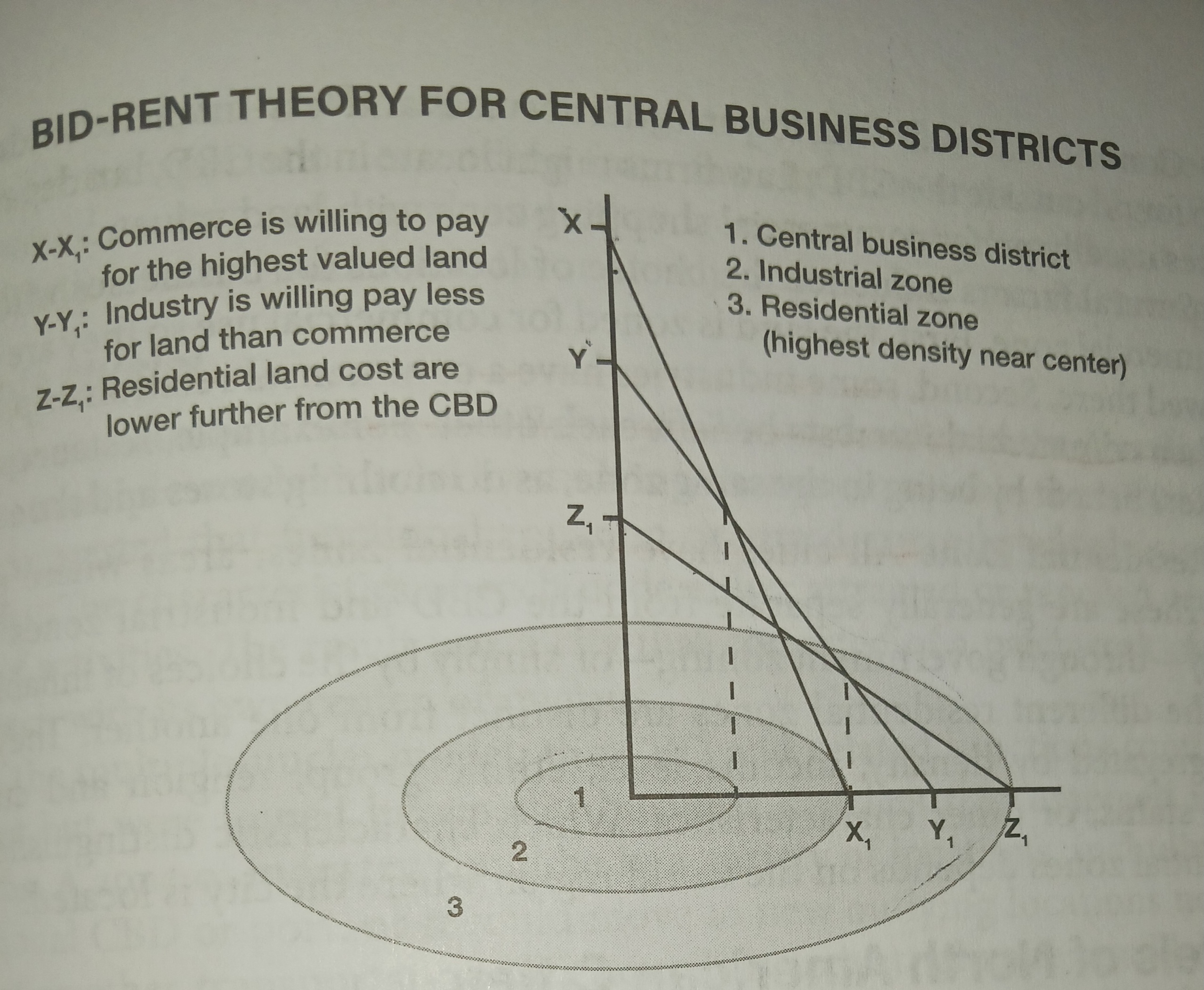
bid-rent theory
the amount of land different land users are prepared to pay for locations at various distances from the city center, resulting in a tendency for a concentric pattern of land use
creator: William Alonso
How does this impact the types of buildings being built in certain areas of the urban area?
Near the city center, where land values are highest, tall buildings and high-density developments prevail to accommodate businesses seeking prime locations. Transition zones feature a mix of commercial and residential buildings with medium-density developments, while suburban areas prioritize lower-density housing such as single-family homes and shopping malls.
Bid Rent Strengths and Weaknesses
Strengths:
1. Intuitive Understanding: The bid rent theory is relatively simple and intuitive, making it accessible for understanding urban land use patterns. Many people may have observed bid rent principles in action while shopping or browsing for apartments without even realizing it.
2. Historical Relevance: The theory has historical relevance and has been used to explain urban land use patterns for decades. It provides a framework for understanding how land values and land use evolve in relation to distance from the central business district (CBD).
3. General Applicability: The bid rent theory offers a general framework that applies to many cities around the world. It helps to explain the typical pattern of CBD-Industrial District-Residential Districts found in many urban areas.
Weaknesses:
1. Disruption by Online Commerce: The rise of online shopping undermines the traditional relationship between physical location and profit margins, challenging the assumptions of the bid rent theory. As online commerce grows, the competition for physical retail space within CBDs may decrease, affecting the accuracy of bid rent predictions.
2. Variability in Urban Organization: Not all cities conform to the CBD-Industrial District-Residential Districts pattern. Some cities, like Tokyo with multiple CBDs, or suburban-developed cities like Chesapeake, Virginia, may not have a discernible CBD. In such cases, the bid rent theory may not be applicable or may require modification.
3. Uncertainty in Long-Term Effects: While rural-to-urban migration patterns are generally steady, the long-term effects of the Internet on residential population distributions remain uncertain. Changes in technology and lifestyle trends could further disrupt traditional urban land use patterns, potentially diminishing the relevance of the bid rent theory over time.
blockbusting
rapid change in racial composition of residential blocks in American cities due to real estate agents encouraging out-migration for profit
Effects of blockbusting
1. Racial Segregation: Blockbusting made racial segregation worse by scaring white people into leaving neighborhoods when black families moved in. This made certain areas mostly white or mostly black, creating divisions in cities.
2. Income Inequality: Blockbusting made it harder for both white and black families to make money. White families were pressured to sell their homes for less money, while black families faced discrimination in finding homes and loans.
3. White Flight and Suburbanization: Blockbusting sped up white flight, where white families left cities to avoid living near black families. This made suburbs grow as more white families moved there, leaving behind mostly black neighborhoods in cities.
4. Great Migration: Blockbusting happened during the Great Migration, when millions of black people moved from the South to cities in the North and West. This changed how cities looked and made racial tensions worse.
5. Failure of Urban Renewal: Government programs meant to fix run-down areas often made things worse. They kicked out poor and black families without helping them find new homes or jobs. Rich people and businesses benefited more from these programs.
6. Unequal Access to Help: Poor and black communities got less help and support compared to rich and white areas. This made inequalities in housing and jobs even worse.
boomburb
a rapidly growing city in the United States that remains essentially suburban, even as it reaches populations more typical of urban core cities
brownfields
any previously developed land that is not currently in use that may be potentially contaminated.
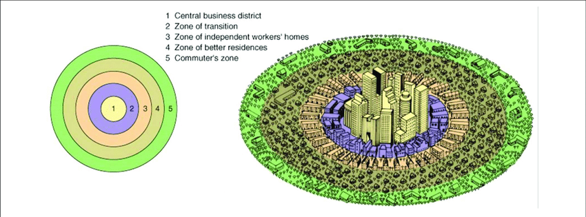
concentric-zone model
a model describing urban land uses as a series of circular belts or rings around a core central business district; that mobility is directly related to land value. By mobility, we mean the number of people who pass by a given location on an average day. The greater the number of people who pass by, the more opportunities there are to sell them products, which means that more profit will be made there.
creator: Ernest Burgess
pros and cons of the concentric zone model
Strengths:
1. Good for US Cities in Early 1900s: The CZM works well for understanding how American cities grew in the early 1900s, especially with lots of immigrants coming in. It helped people figure out what was happening in big US cities.
2. Influential for Urban Planning: The CZM inspired other models that came after it, like the Hoyt Sector Model and the Multiple-Nuclei Model. These newer models built on what the CZM started, helping planners deal with changes in cities, like more cars.
Weaknesses:
1. Limited Use Outside US and After 1950: The CZM doesn't work well for other countries or after around 1950. Using it in those situations can lead to mistakes because it's not meant for them.
2. Misses Important Stuff: The CZM doesn't think about things like geography or how cars changed cities. It also doesn't talk about racism and how it kept some people from living where they wanted.
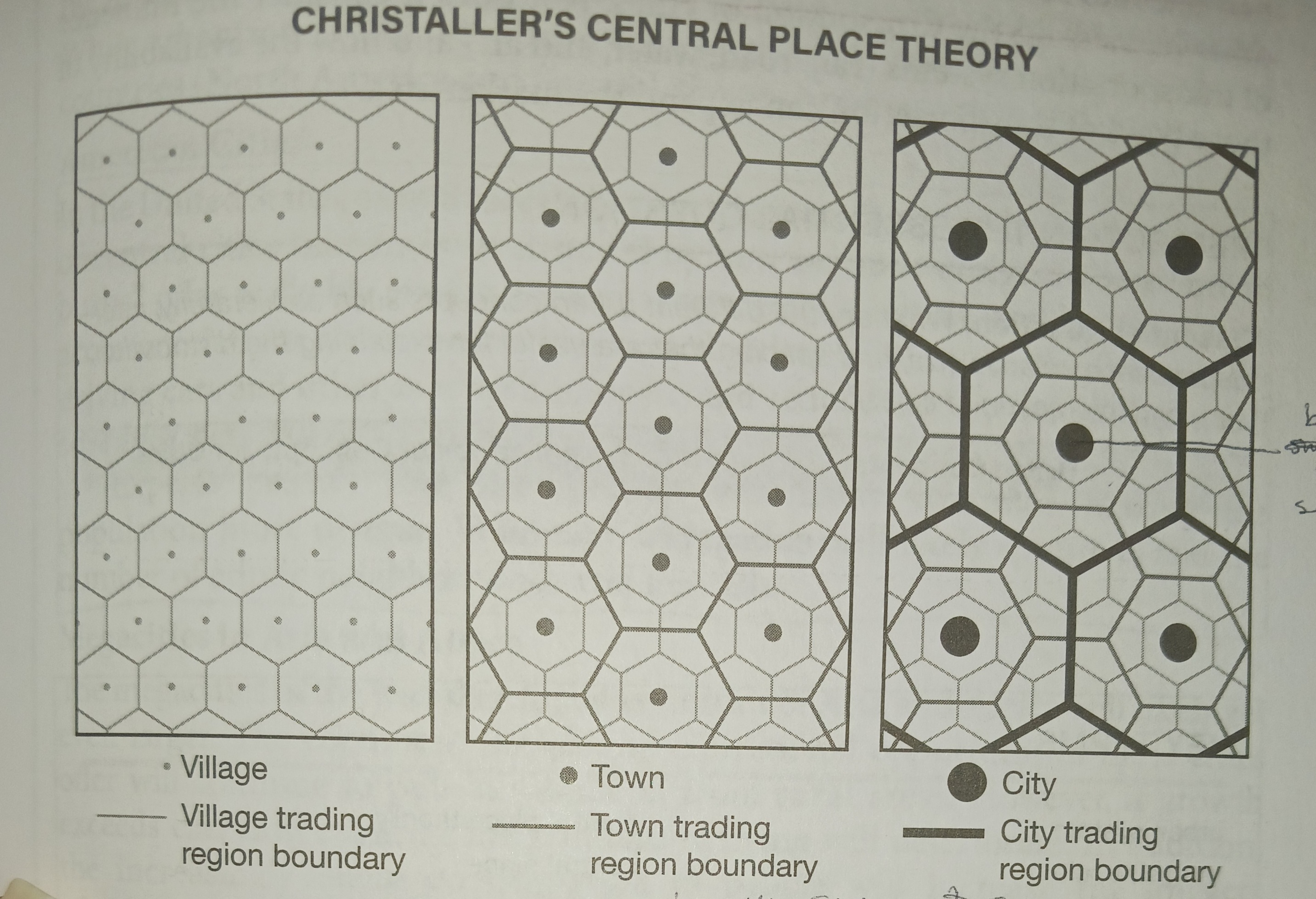
central place theory
a theory explaining the relative size and spacing of towns and cities as a function
creator: Walter Christaller
strengths and weaknesses of Central Place Theory
Strengths:
1. Influence in Retailing: CPT has had a big impact on how businesses decide where to open stores. It's often used in economic models to help retailers figure out the best places to put their stores. This predictive power is one of its best qualities.
2. Inspiration for Variation: CPT inspired lots of other ideas and theories. When people said it didn't fit their area, they worked on new ways to describe what was happening. This led to a better understanding of different patterns in different places.
Weaknesses:
1. Limited to Specific Conditions: CPT doesn't work well in every situation. The patterns it describes might not match what's happening in different parts of the world. For example, the way towns are arranged in southern Germany might be different from other places.
2. Too Focused on Economics: Some people think CPT puts too much emphasis on money and not enough on other important factors, like politics or culture. It might not explain why people settle in certain places as well as it explains where businesses set up shop.
In simple terms, Central Place Theory is good for understanding where businesses should open stores, but it doesn't fit everywhere, and it might not explain everything about why people settle in certain places.
de facto segregation
racial, ethnic, or other segregation resulting from societal differences between groups without institutionalized legislation intended to segregate
disamenity zone
the very poorest parts of cities that are not even connected to city services and are controlled by gangs and drug lords’
Ex. Favelas
ecological footprint
the impact of a person or community on the environment, expressed as the amount of land required to sustain their use of natural resources
edge city
distinct sizable nodal concentration of retail and office space of lower than central city densities and situated on the outer fringes of older metropolitan areas
exurb
a district outside a city, especially a prosperous area beyond the suburbs
farmland protection policy
discourages Federal activities that would convert farmland to non agricultural purposes.
why was the Farmland Protection Policy Act created
to address concerns about the loss of agricultural land to urbanization, industrialization, and other non-agricultural uses. By discouraging federal activities that could lead to the conversion of farmland, the act aims to preserve agricultural resources, maintain food production capacity, support rural economies, and promote environmental sustainability.
favela
the Brazilian equivalent of a shanty town, generally found on the edge of the city, constructed from a variety of materials; the homes are built by civilians n government land
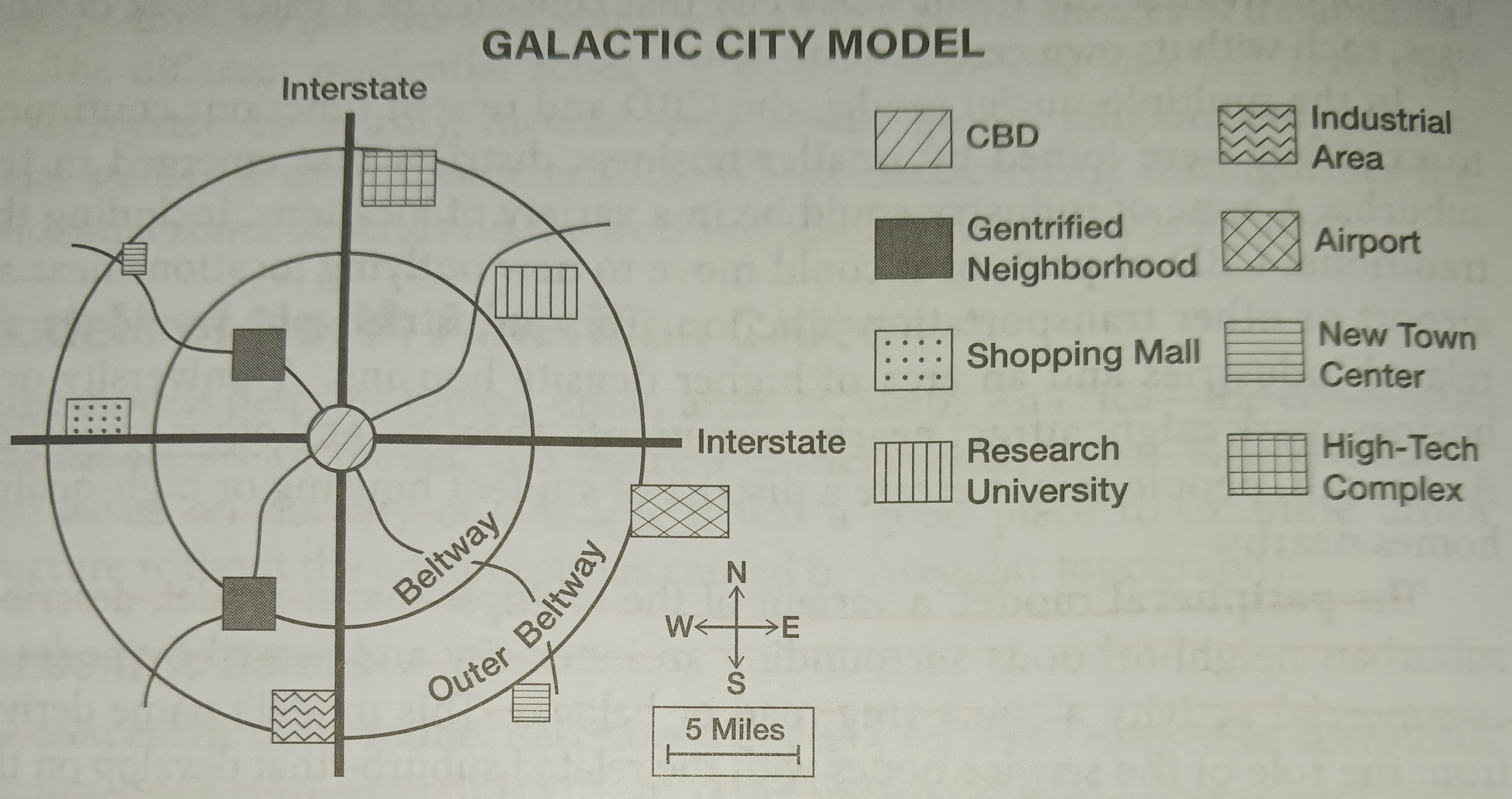
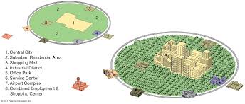
galactic city model
a modern city with dispersed industrial parks, shopping centers, and edge-city downtowns as the new centers of economic activity; multiple CBD’s
creator: Peirce F. Lewis
pros and cons of the Galactic City
Pros:
1. Expands on the Multiple Nuclei Model: The Galactic City concept builds upon the Multiple Nuclei Model by illustrating how the automobile and suburbanization have influenced urban development. It shows how mass-produced suburban forms, like Levittowns, have become common across the country, regardless of local geography.
2. Helps Understand Cultural Landscape: It helps cultural geographers understand the repetitive and mass-produced nature of the American landscape. The concept highlights how local diversity has been replaced by standardized forms created by corporations, like McDonald's, and embraced by people who choose housing that looks the same everywhere.
3. Relevance in the Telecommuting Era: With the rise of telecommuting facilitated by the internet, the Galactic City concept becomes increasingly relevant. It suggests that people may want urban amenities even in rural areas, leading to the spread of urban elements beyond traditional city boundaries.
Cons:
1. Not Urban-Centric: The Galactic City concept isn't specifically focused on urban areas, so it might not be very useful for describing cities, especially from an economic perspective.
2. Limited Application to Rural Areas: It doesn't apply well to genuinely rural areas, which still make up a significant portion of the US. The concept mainly focuses on urban forms near major road junctions and incorporates urban structures into rural towns, leaving much of the rural landscape unaccounted for.
Galactic City Model criticism and misunderstanding
1. Misinterpretation as Multiple-Nuclei Model Extension: Some critics mistake the Galactic City Model as merely an expansion of the Multiple-Nuclei Model or see it as interchangeable with concepts like "edge cities." However, its creator, Peirce Lewis, clarified that it goes beyond these frameworks.
2. Different from Megalopolis: While the term "megalopolis" describes a continuous urban area stretching from Maine to Virginia, the Galactic City Model encompasses various types of cities, not just one type of urban form. Lewis emphasized this distinction.
3. Critique of "Sprawl" Terminology: Lewis criticized the term "sprawl" for its negative connotations, as it implies that urban expansion outside traditional cores is unnatural. Instead, he aimed to convey that this urban form has become synonymous with the US itself, reflecting its widespread nature.
gentrification
when middle and upper-class individuals move into traditionally working-class areas in a city, renovating or building homes and businesses, which raise property values. In turn, increased property values also increase rent prices, making housing too expensive for the original working-class tenants, who are primarily renters. These original residents then have to move to cheaper areas outside their homes and communities
Pros and cons of gentrification
Pros | Cons |
|
|
White flight
the process wherein white people, or people of different European ancestries, moved out of mixed urban areas to economically and racially homogenous suburban and rural areas.
Solutions to Gentrification
Affordable housing programs and historical preservation laws help residents stay in their communities by providing affordable housing options and preserving the character of neighborhoods. Governments can also invest in urban renewal projects before gentrification starts, improving community services and creating opportunities for wealth growth within historically underprivileged areas. These measures aim to counter the negative effects of gentrification and support the needs of existing residents.
globalization
actions or processes that involve the entire world and result in making something worldwide in scope
Ex: McDonald; its fast-food operations in numerous countries worldwide, adapting its menu to local preferences. This global presence not only standardizes aspects of consumer culture but also raises discussions about the impact of multinational corporations on local economies and cultural practices.
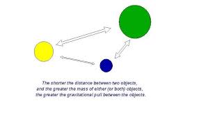
gravity model
a mathematical prediction of the interaction of places, based on population size and distance between them; like gravity the bigger and closer to places are the more they are gonna interact
creator: issac newton
greenbelts
an area of open land around a city, on which building is restricted; used to counter urban sprawl
pros and cons of green belts
Pros:
They prevent urban sprawl.
They stop neighboring towns from merging. By protecting the towns from merging into each other, each town's distinctive character and culture can be protected.
They allow the preservation of the countryside for agriculture and recreation within a reachable distance for the urban residents.
They assist in urban regeneration by encouraging developers to use brownfield urban land rather than greenfield agricultural land.
The open green space assists in the conservation of wildlife as it is protected from development. Green belts are also referred to as the city's 'green lungs' and help with the air quality.
Cons:
House prices often increase in these areas as the urban area is restricted to new housing. When more people are looking for homes than are available, the prices rise, forcing poorer people to have to move out of the area. Affluent suburban and rural-urban residents are more likely to be able to afford homes in these areas, pushing the less affluent who are seeking more affordable housing out of the area.
It is difficult to constrain the growth of an urban area with a growing population and can lead to 'leap-frog' development, the new development at the outer edge of the green belt. This consequently puts pressure on these outer areas and can lead to further sprawl.
Despite the ideal nature of protected land as wild and natural, the green belt has been used for intensive farming. While farming is necessary for producing food, it is not always beneficial to the environment.
Greenbelt land is not always accessible to the public as the land is often privately owned.
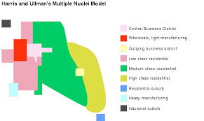
multiple nuclei model
The Multiple Nuclei Model explains cities with multiple centers based on different types of economic activities. It suggests that certain businesses attract others to their locations, while some economic activities prefer to be in separate areas. Additionally, real estate affordability influences where businesses are located within the city.
creators: Edward Ullman and Chauncy Harris
what does the multiple nuclei model improve on
improves on two influential but limited models, the Hoyt Sector Model from 1939 and the Burgess Concentric Zone Model of 1925.
pros of the multiple nuclei model
The Multiple Nuclei Model is helpful because it recognizes how cities have spread out with the rise of cars and the road networks around them. It shows how new areas develop along highways and ring roads, while the central parts of cities become less important for jobs and businesses. This model helps us understand how cities change and grow over time, especially in terms of where people work and live.
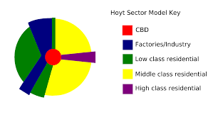
sector model
a description of urban land uses as wedge-shaped sectors radiating outward from the CBD along transportation corridors
creator: Homer Hoyt
pros and cons of the sector model
Strengths of the Hoyt Sector Model:
1. Adjustable for Spatial Expansion: Unlike the concentric rings model, Hoyt's sector model can adapt to urban growth. Sectors can expand outward due to factors like CBD expansion, in-migration requiring new housing, and residents changing socioeconomic status and moving to different neighborhoods.
2. Useful for Urban Planning: The model provides urban planners, governments, and private sectors with a useful tool for formulating policies related to real estate, financing, land use, transportation, and zoning by conceptualizing urban sectors.
Weaknesses of the Hoyt Sector Model:
1. Simplification of Reality: Like all models, Hoyt's sector model oversimplifies reality and needs modification for local conditions influenced by physical geography, history, or culture.
2. Cultural Factors Not Fully Considered: The model primarily focuses on economic factors and may overlook cultural preferences, such as ethnic or religious groups preferring to live together regardless of income levels.
3. Decline of CBD Importance: The model's emphasis on the CBD's centrality may not reflect modern urban dynamics where CBDs have lost space and jobs to other city centers along highways, leading to the rise of multiple downtowns.
4. Limited Consideration of Physical Geography: While the model accounts for some physical geography factors, it may not fully address specific conditions in each city, such as mountains or lakes, which can alter the model's form.
5. Neglect of Automobile Dominance: The model fails to consider the dominance of automobiles as the primary mode of transportation, leading to the wholesale abandonment of central cities by affluent individuals and reshaping urban structures.
inclusionary zoning
municipal and county planning ordinances that require a given share of new construction to be affordable by people with low to moderate incomes
infilling
new building on empty parcels of land within a checkerboard pattern of development
Different types of infilling
In residential development, the goal is to add more homes to the area. This often means building multi-family units like duplexes and townhomes to make the neighborhood denser.
Mixed-use development means buildings or areas that have homes, shops, and other things all together.When we talk about mixed-use at a building level, it's usually planned using infill, which means filling in space in cities. This kind of development aims to put homes and services close together so people can walk or use public transit easily.
Transit-oriented development uses existing infrastructure like public transportation. If there are apartments or mixed-use buildings within about a 10-minute walk from a bus or train stop, we call it transit-oriented development because it encourages people to use public transit.
Some abandoned lots may already have existing structures and buildings. Brownfields are previously commercial or industrial areas that are underused or abandoned and may have issues with contamination. Brownfield development will usually require clean-up and site treatment to be deemed safe to use.
Greyfields are similarly underused or abandoned buildings that were previously commercial or retail spaces. Unlike brownfields, greyfields usually don't have contamination issues but may need investment to replace or renovate buildings.
Urban blight
the abandonment and deterioration of areas within a city.
infrastructure
the underlying framework of services and amenities needed to facilitate productive activity
land tenure
a complex social institution that governs the relationship among people concerning assets such as land, water bodies, and forests
why is land tenure important
Land tenure is a crucial concept because it defines rights, responsibilities, and relationships concerning land and natural resources, influencing access, use, and control over these assets. Clarifying land tenure systems helps prevent conflicts, promote social equity, and foster sustainable management of land and resources. Understanding land tenure is essential for effective land governance, economic development, and environmental conservation efforts in both rural and urban contexts.
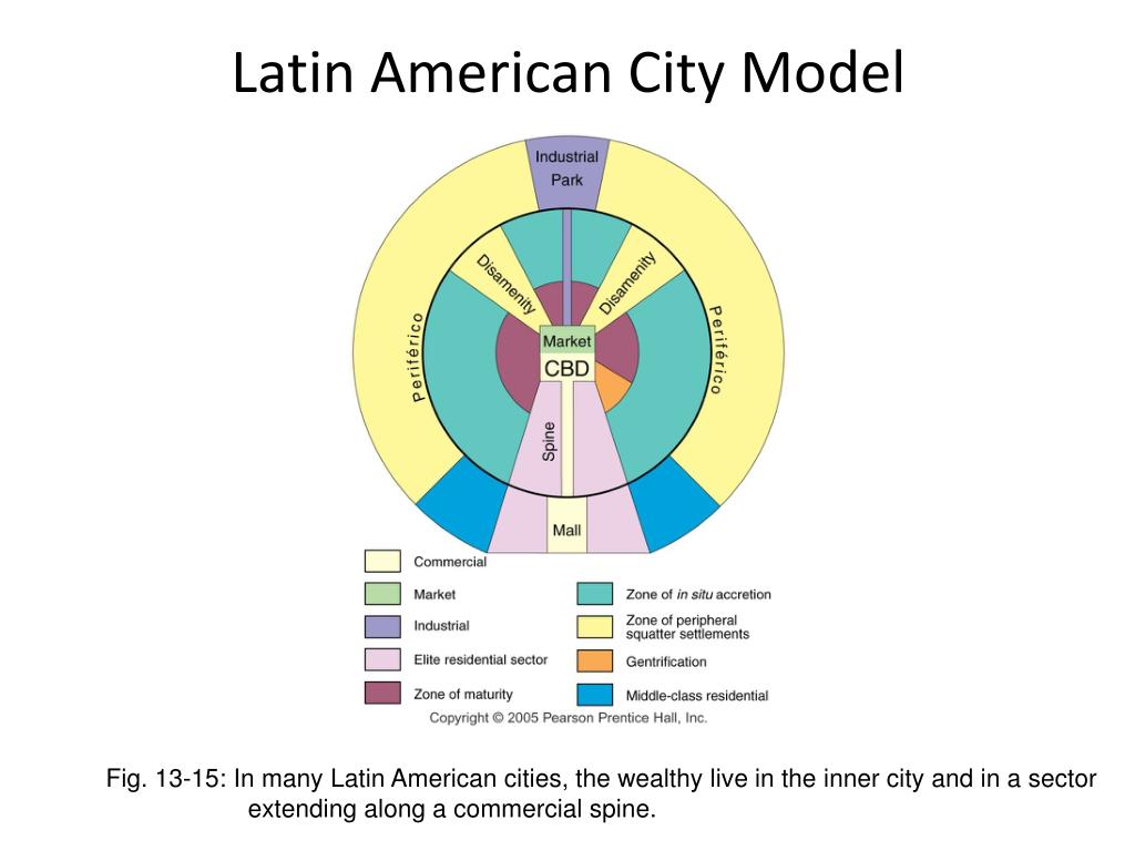
Latin American city model
a model showing a central business district, one dominant elite residential sector, and a commercial spine surrounded by concentric zones
creators: Ernest Griffin and Larry Ford
local food movement
aims to connect food producers and consumers in the same geographic region, to develop more self-reliant and resilient food networks
Strengths and weakness of the Latin model
Strengths of the Latin City Model:
1. Historical Significance: The Latin City Model reflects the layout and design of ancient Roman cities, which were influential in shaping urban development across Europe and beyond. It provides insight into the origins of urban planning principles.
2. Compact and Walkable: The Latin City Model typically features a compact layout with narrow streets and dense development, making it walkable and fostering a sense of community and interaction among residents.
3. Centralized Core: The model often includes a centralized core, such as a forum or plaza, which serves as a focal point for social, political, and commercial activities, enhancing the city's vibrancy and identity.
Weaknesses of the Latin City Model:
1. Limited Adaptability: The Latin City Model may not be suitable for modern cities with different needs and challenges. Its rigid structure may hinder flexibility and adaptation to contemporary urban dynamics.
2. Transportation Challenges: The narrow streets and dense development characteristic of the Latin City Model can pose challenges for modern transportation systems, including traffic congestion and limited parking options.
3. Social Equity Concerns: The centralized core of the Latin City Model may result in disparities in access to resources and opportunities, with marginalized communities potentially facing exclusion from the city's main hub of activity.
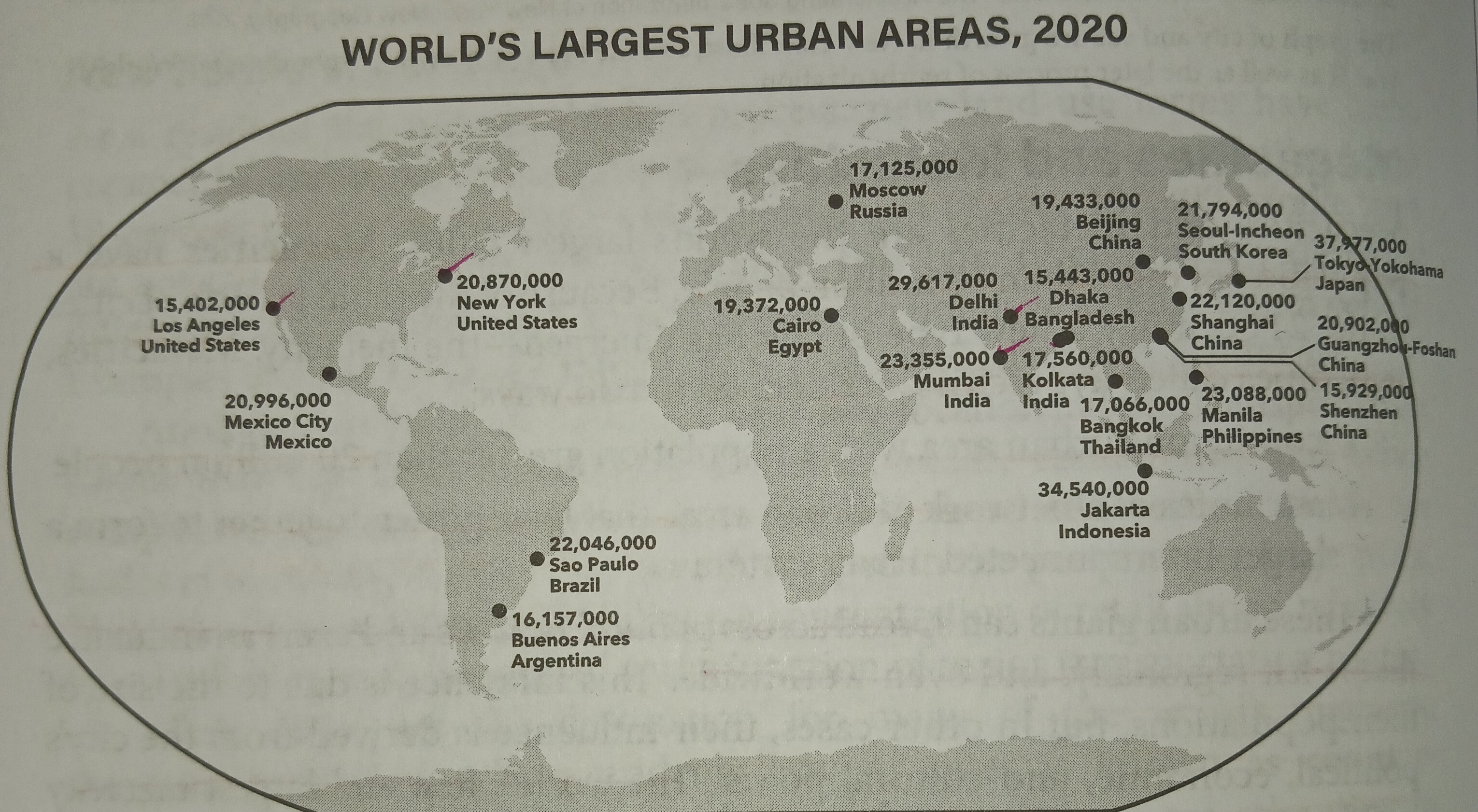
megacities
a very large city metropolitan area, typically with a population of more than 10 million people
ex. New York City, Shanghai, Lima, Mumbai, Osaka
meta cities
a very large city metropolitan area, typically with a population of more than 20 million people
ex. Lagos, Mexico City, São Paulo, Tokyo, Moscow
mixed land use
a range of complementary land uses located together in a balanced mix, including residential development, shops, employment community, and recreation facilities
New Urbanism
a planning and development approach based on walkable blocks and streets, housing and shopping nearby, and accessible public spaces
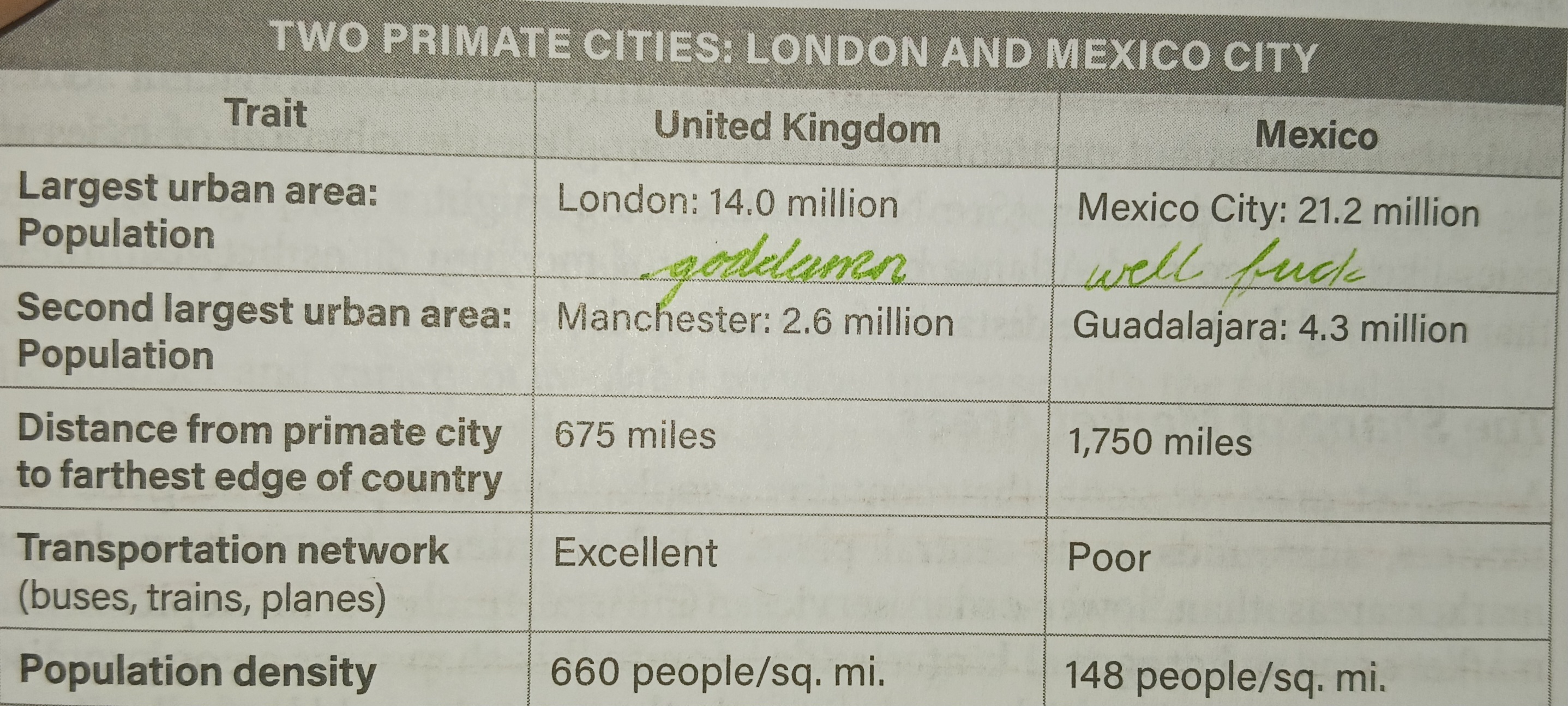
primate city
a city of large size and dominant power within a country; largest of the country, most expressive of the national culture
ex: Manila, Cairo, Mexico City, Paris, Buenos Aires, Sydney
criticisms of primate city
Criticism of the Primate City:
1. Marginalization of Other Areas: Primate cities, being the dominant urban centers, often receive disproportionate attention and resources, leading to the neglect of other regions within the country. This imbalance can hinder overall development and perpetuate disparities.
2. Colonial Context: The theory of primate cities emerged during a period of colonialism and industrialization, primarily focusing on developed countries like London and Paris. However, as former colonies gained independence and underwent urbanization, the application of this theory to developing countries led to negative associations and challenges in defining the role of primate cities in these contexts.
Overall, while primate cities may wield significant influence, their dominance can lead to uneven development and challenges in understanding their role, particularly in the context of developing countries undergoing rapid urbanization and socioeconomic change.
qualitative data
descriptive statements based on observations, interviews, or evaluations
quantitative data
measures of values or counts expressed as numbers, more objective and easily transformed into statistics
range
in central place theory, the average maximum distance people will travel to purchase a good or service; the smaller the range the more people or willing to go to this place, like a low rage is an boutique shop vice versa would be a football stadium
rank-size rule
in a model urban hierarchy, the population of a city or town is inversely proportional to its rank in the hierarchy. The rank-size rule says that the second-largest city will have half the population as the largest. The third largest city will be one-third the size, and the fourth will be one-quarter the size of the largest, and so on; hand and hand with primate city
pros and cons of rank- size rule
Strengths of the Rank-Size Rule:
1. Development and Urbanization: Countries following the rank-size rule tend to be more developed with a long history of urbanization, indicating overall strength and progress.
2. Even Development: Rank-size distribution suggests more even development across multiple cities, reducing inequality and promoting balanced growth.
3. Resilience and Security: Diverse large cities spread resources and wealth, making a country more resilient and secure by avoiding overreliance on a single city.
Disadvantages of the Rank-Size Rule:
1. Undefined City Boundaries: Lack of a clear definition for city boundaries can lead to subjective adjustments to fit the rule, potentially distorting the accuracy of city sizes.
2. Estimation Inaccuracy: Rank-size rule provides rough estimates of city sizes, which may be imprecise, especially in large countries, leading to significant discrepancies.
3. Limited Applicability: Not all countries follow the rank-size distribution, with many having primate cities instead. This limits the rule's accuracy in predicting the sizes of other cities within a country.
redevelopment
any new construction on a site that has pre-existing uses. It represents a process of land development used to restore the physical, economic and social fabric of urban space.
redlining
The practice of withholding financial loans and services to residents in urban neighborhoods is considered high-risk or undesirable. These neighborhoods had predominantly minority and low-income residents, which prevented them from purchasing property, homes, or investing in communities.
Effects of redlining
exacerbated racial segregation
income inequality
financial discrimination.
remediation
the action of reversing or stopping environmental damage
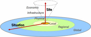
situation
the relative location of a place
situation
the relative location of a place
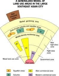
Southeast Asian city model
The Southeast Asian City Model shows how cities in Southeast Asia are busy and diverse. They have a central area for businesses surrounded by growing neighborhoods and informal businesses. These cities also have lots of ways for people to get around, like roads and trains.
creator: Terrance Garry McGee.
pros and cons of the Southeast Asian city model
Limitations:
1. Variation: Southeast Asian cities differ greatly, making it hard for one model to fit all.
2. Informality: The model might not capture the informal aspects like settlements or businesses common in these cities.
3. Rapid Change: Cities are growing quickly, and the model might not keep up with the fast changes.
Advantages:
1. Diversity: It shows the different features of Southeast Asian cities.
2. Common Traits: Helps find shared traits like mixed land use or dense cores.
3. Planning Aid: Can guide urban planning efforts by highlighting important urban features and trends.
squatter settlement
any collection of buildings where the people have no legal rights to the land they are built upon
suburb
an area on the outside of big cities and towns where people live. It's sort of in-between a city and the country. It's not super crowded with tall buildings, but it's not wide open space either. The suburbs form a ring outside of a major city with the density of houses getting less away from the city.
suburbanization
a movement of upper and middle-class people from urban core areas to the surrounding outskirts to escape pollution and deteriorating social conditions
suburban sprawl
the unrestricted growth outside of major urban areas with separate designations for residential
causes for suburban sprawl
Suburban sprawl happens because housing in cities becomes too expensive for many people, so they look for cheaper homes outside the city. As more people move into cities, finding a home becomes harder and prices go up even more. Also, there's not enough good planning for cities and nearby areas, so it's easier and cheaper for builders to make homes in sprawling places. Plus, more highways and roads make it easier to drive from the suburbs to the city, encouraging more people to live farther away. These things together create suburban sprawl, changing how cities and neighborhoods look.
cons of suburban sprawl
Suburban sprawl causes a lot of problems, one of them being that people rely too much on cars, not just in the suburbs but also in US cities. Even if you live in the city, you might still need a car because things are too spread out. When places are far apart, it takes longer to get there, and you end up needing a car to get around. But if public transportation is good and you can walk or bike, you don't need a car as much. The thing is, when everyone depends on cars, it costs a lot of money, especially for people who don't have much. This can make it hard for lower-income folks who can't afford a car, as well as the elderly and kids who can't drive. suburban sprawl is also linked with land loss, higher vehicle travel, resource use, energy consumption, and greenhouse gas emissions.
sustainable design initiatives
initiatives that seek to reduce negative impacts on the environment, health, and comfort of building occupants
threshold
in central place theory, the population size required to make the provision of services economically feasible. examples of places that have low thresholds are Convenience stores, Pharmacies, Neighborhood cafes, Dry cleaners, Hair salons
transportation-oriented development
the creation of compact, walkable, pedestrian-oriented, mixed-use communities centered around high-quality train systems
urban decentralization
the movement of people working in the city to communities with lower taxes on the fringe of the metropolitan region
urban growth boundary
a regional boundary set to control urban sprawl by mandating urban development inside and preservation outside
urban hierarchy
a ranking of settlements according to their size and economic function
e.g., hamlet - village - town - city - metropolis.
Describe how the rural areas are different from the urban areas
In the context of the graphic discussed in class, rural areas are typically characterized by lower population densities, larger land parcels, and a greater prevalence of agricultural and natural landscapes. Urban areas, on the other hand, exhibit higher population densities, more compact land use patterns, and a concentration of built infrastructure such as buildings, roads, and utilities. Rural areas often feature dispersed settlement patterns with fewer amenities and services, while urban areas are characterized by centralized development, higher levels of economic activity, and a wider range of services and amenities catering to a denser population. Additionally, rural areas may have limited access to transportation and public services compared to urban areas, which tend to have more extensive infrastructure and resources.
urban renewal
the rehabilitation of city areas by renovating or replacing dilapidated buildings with new infrastructure
urban sprawl
unrestricted growth in many American urban areas of housing, commercial development, and roads over large expanses of land, with little concern for urban planning.
urban sprawl consequences
habitat fragmentation, water and air pollution, increased infrastructure costs, inequality, and social homogeneity
urban sustainability
the idea that a city can be organized without excessive reliance on the surrounding countryside and be able to power itself with renewable sources of energy
urban walkability
a measure of how friendly an area is to walking
urbanization
the population shift from rural areas to urban areas, and how each society adapts to this change
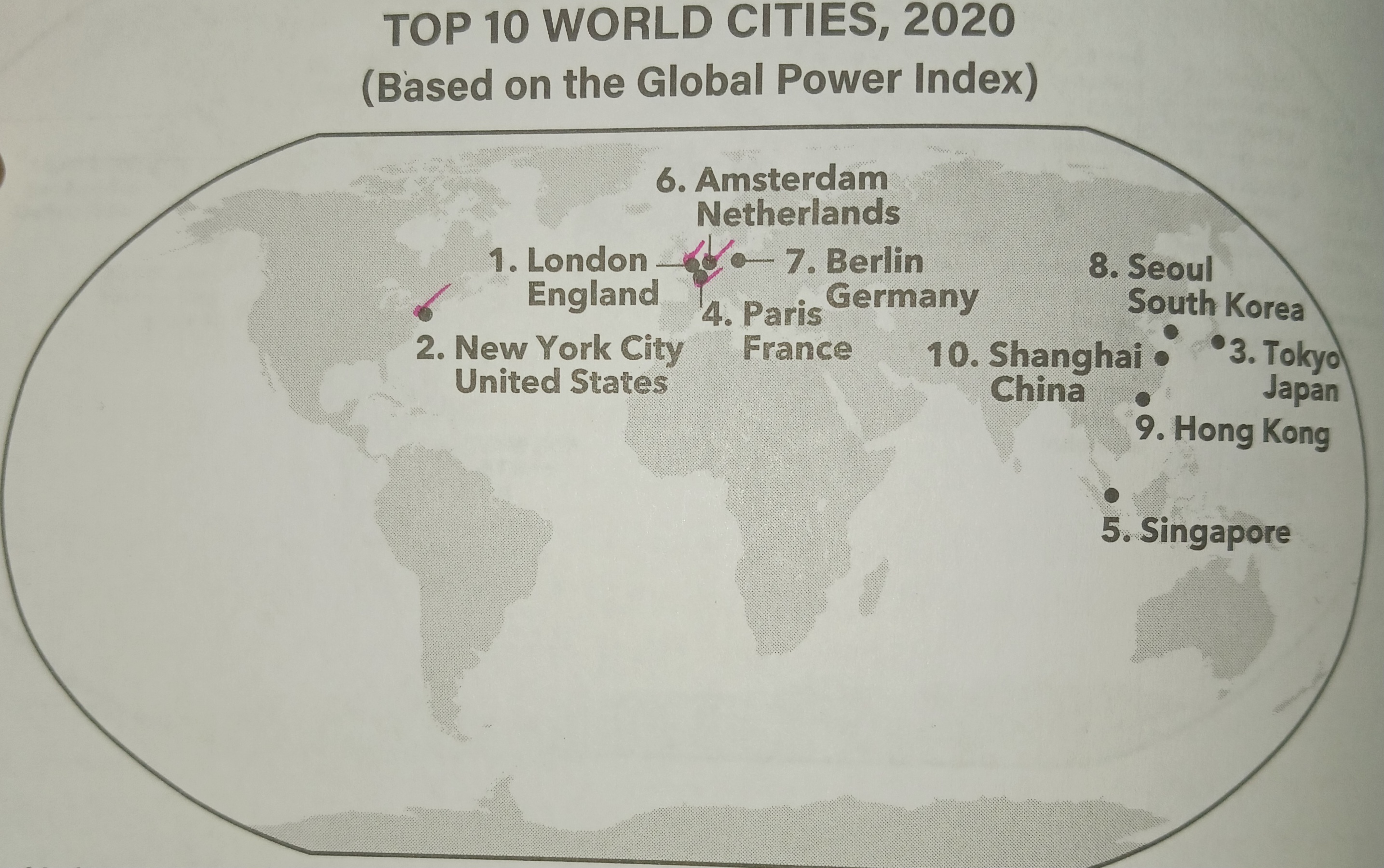
world city
one of the largest cities in the world, generally with a population of over 10 million; has a impact ecomnicaly, socially, and political global
zone of abandonment
areas that have been deserted in a city for economic or environmental reasons
ecumene
industrial and agricultural land that is permanently used to sustain the human population.
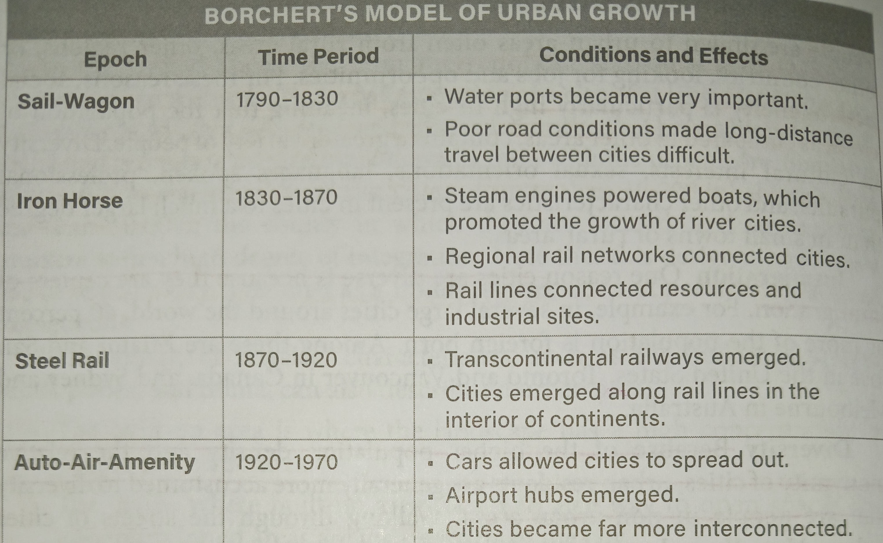
Epochs of Transportation Growth
Borchert's Epochs of Transportation Growth is a model that categorizes the history of urban development based on changes in transportation technology. It identifies four epochs and explains how transportation advancements shape the expansion of cities.
Urban Areas
Metropolitan area
A collection of adjacent cities economically connected across which population density is high and continuous
Nodal region
Focal point in a matrix of connections
Pedestrian cities
City shaped by the distances people could walk
Connerbation
Uninterrupted urban area made of town suburbs and cities
Residential zones
Areas where people live
Functional Zonenation
The idea that portions of an urban area regions or zones within a city have specific and distinct purposes
Commensal relationship
When commercial interests benefit each other for example restaurants and theaters benefit by being in the same Zone
Peripheral model
A variant of the multiple nuclei model describes Suburban neighborhoods surrounding an inner city and certified nodes of commercial activity along a Ring Road or Beltway
creator: harris
Citadel
A fort designed to protect the city with its related Palace and barracks for soldiers