


UGA GEOG1111 Chapter 5
Unit 5 – Water
Weather is a snapshot, Climate is long-term averages
Outgassing -> initial water from icy comets
Water is a polar molecule – one side is positive, one side is negative. Because of the charge, water is a very good solvent (can dissolve all sorts of salts)
Water is also fairly dense, but the solid form is less dense than the liquid form,.
Water occurs on earth in all 3 states naturally
2 water molecules are easy to separate because they’re only tied together by hydrogen bonds (which makes them very good solvents)
Latent Heat – Comes from solid water (ice) melting into liquid water.
Hydrogen bonds provide surface tension (even though its very weak)
Latent Heat of evaporation – 585 cal. Absorbed
Latent of condensation – 585 cal. Released
Humidity – Water vapor in the air
Humidity is a function of temperature (The warmer it is, the more moisture in the air)
Relative Humidity – The amount of water vapor in the atmosphere in comparison to the capacity it could hold (Not a very good measure)
As temperature increases, relative humidity decreases (and vice versa)
Dew-point – Temperature at which condensation occurs (lower in Tucson than Athens)
When the Dew-Point is close to the air temperature, you will sweat. If its further, you won’t sweat.
Saturation Vapor pressure is the maximum possible water vapor as measured by the pressure it exerts (mb)
Saturation vapor pressure increases as air temperature does.
Saturation vapor pressure is lower over ice than water of the same temp.
Stability is the tendency of an air parcel to remain in place or to change vertical position.
This buoyancy is controlled by the density of the air (less dense air rises, denser air sinks)
Adiabatic means occurring with a loss or gain of heat
Adiabatic heating and cooling occur because of compression or expansion of an air parcel caused by changes in altitude
Rising air expands and cools, sinking air is compressed and warms
Parcel of air is 32 degrees at sea level, every 1000m it rises, it drops 10 degrees Celsius (dry adiabatic lapse rate). Temperature drops as it rises, and increases as it descends.
Dry Adiabatic Lapse Rate (DAR) is the rate at which dry air cools by expansion (ascending) or heats by compression (descending)
Dry means the relative humidity is less than 100% (has not reached due point temperature, sponge not full)
Moist Adiabatic Lapse Rate (MAR) is the rate at which saturated air cools by expansion.
Moist refers to air that is saturated (Humidity = 100, reaches due point temperature)
If MAR continues to rise, it forms clouds and precipitation, and releases energy into this parcel.
The MAR is much less than the DAR because latent heat is providing the air with energy.
Lapse Rates are rates of temperature change with change in altitude. Normal Lapse Rate is 6.4C/1000m
Environmental Lapse Rate (ELR): varies
Once a parcel of air gets to the Dew Point temperature, clouds start forming. The parcel will still continue to rise, but now it is rising at the MAR instead of the DAR because latent heat is being released into the cloud.
Absolutely Stable – ELR less than DAR, meaning the parcel will always be colder than the surrounding environment. This means the parcel will be denser and will resist upward movement.
Absolutely Unstable – Happens when the environmental lapse rate is greater than the DAR, causing the parcel to be warmer (less dense) than the surrounding environment, causing it to continue to rise.
Four cloud types (altitude): Low (0-2000m), Middle/Alto (2000-6000m), High (6000-13000m)
Also Vertically Developed (0-13000m) span all 3 levels – Cumulonimbus
Three cloud types (appearance): Cirroform (hairlike, feathery), Stratiform (flat and layered), & Cumuliform (dense, heavy)
Stratus = layered
Nimbo = rain
Cumulous = fair weather
Alto = Middle
Cirro = High, Wispy
Cumulonimbus – Has updrafts (air rising to top) and downdrafts (air sinking to bottom). Produces microbursts (changes in wind direction) which is dangerous for planes. Liquid water droplets are in the lower part, but the extend up much higher than that. Up top (above 6000m) Ice crystals are produces at -40C. Ice crystals are water droplets forced to the top of the cloud. They get larger and larger the more that this cycle happens, leading to hail.
Fog is a cloud at ground level. Its caused by warm, moist air next to the ground being cooled to dew-point temperature. Classified by cooling mechanism.
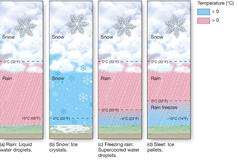
Precipitation occurs when water droplets or ice crystals become large enough to fall due to gravity.
In warm clouds (above freezing), this occurs due to the collision-coalescence mechanism. Water molecules adhere to the condensation nuclei, and if the cloud droplet gets large enough, it drops, encounters more water molecules, and gets larger. The largest ones get pulled down to earth’s surface (rain).
In cold clouds, this occurs due to the Bergeron process. The Bergeron process states that these ice crystals grow the super cool water from the clouds to grow larger, forming snow.
Hail: Liquid water forms and gets carried high by an updraft where it freezes, which repeats and leads to larger and larger and larger ice balls. The greater the storm, the greater the vertical extent, the higher it can go, the larger the stones gets.
Air mass – body of air with characteristic temperature, humidity, and stability (source region)