


UGA GEOG1111 Chapter 6
Moisture: m = maritime (relative moist), c = continental (relatively dry)
Temperature: A = Arctic, Polar, Tropical, Equatorial, AAntarctic
Air masses influences NA: m, c, A, P, T


As air masses migrate, their temperature and moisture characteristics modify and slowly take the characteristics of the land they pass over. Lake-effect snow belt of the Great lakes – Snow clouds around new York pick up water from the great lakes causing lots of snow, but where the wind doesn’t go up to cities (Ontario) theres less snow.
Atmospheric Lifting Mechanisms:
Convergent Lifting (flow to low pressure)
Convectional Lifting (local surface heating)
Orographic Lifting (mountains)
Frontal Lifting (Cold and Warm Fronts)
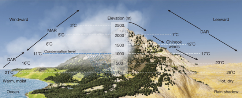
Convergent Lifting – Air flows toward an area of low pressure. Low pressure center: air converges and ascends, causing cooling and condensation. Convectional Lifting – The air above warmer surface is heated and rises (over a parking lot). The warmer surface heats the air above and causes it to rise. Orographic Lifting – Oro = Mountains. Prevailing Winds encounters a mountain range and air is forced to ascend upslope. Windward = Up the Mountain, forms clouds because it gets colder and reaches dew point temperature. Leeward = Down the mountain, really dry side, heats at the DAR. Chinook Winds – Downslope winds on the leeside.
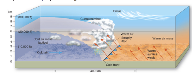
 Frontal Lifting – Cold air front runs into warm air, lifting the warm air off the ground.\
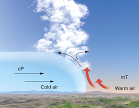
Cold front: Steep face that hugs the ground. Cold air forces warm air aloft, creating cumulonimbus clouds. Very small transition zone
Warm front: Warm air moves up and over cold air. Very Wide transition zone. Warm air rises gradually, leads to nimbostratus, stratus, altostratus, cirrostratus, and cirrus clouds.

Midlatitude Cyclone: Migrating low pressure cells that move in a band with the westerlies. The low pressure center causes a converging counterclockwise cycle. Fronts developed from the cold and warm air meeting. The cyclone moves from west to east while flowing counterclockwise. The cold front advances faster than the center. The warm from advances slower than the center. Because the cold front advances more quickly, the cold front eventually catches the warm front, forming an occluded front. This causes the storm to slowly dissipate.
Weather Forecasting
We get information for forecasting from satellites, weather balloons, ground installations, and the doppler radar.
Necessary data: Pressure, air temperature, dew point temperature, wind speed/direction, cloud type, etc.
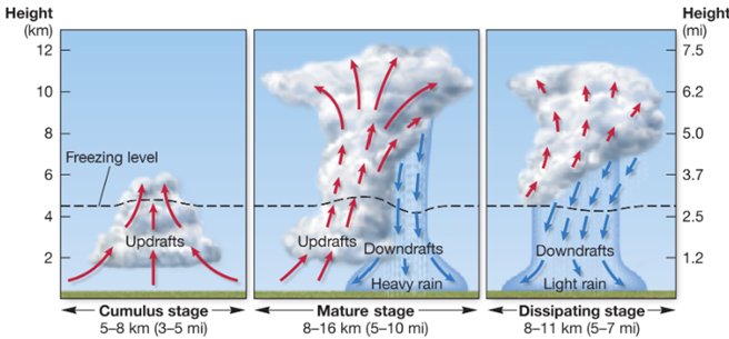
Thunderstorms are powered by the latent heat of condensation. The atmosphere HAS to be unstable and low pressure, causing the atmosphere to rise. Thunderstorms tend to form along cold fronts because cold air lifts the warm air causing a lot of condensation and latent heat release. Updrafts draw more water vapor into the cloud, Downdrafts cause the precipitation and winds at the surface.
Bottom of clouds have negative charge, the ground has a positive charge, causing lightning strikes which hit the ground.
Hailstones are droplets that go through lots of updrafts and downdrafts.