Physical Geography
the study of natural characteristics and the distributions of its features across the Earth.
Human Geography
the study of the events and processes that have shaped how humans understand and alter the Earth
Spatial Perspective
Refers to where something occurs.
Ecological Perspective
Refers to the relationships between living things and their environment.
absolute location
Exact location of a place on the earth described by global coordinates
relative location
The position of a place in relation to another place
place
A specific point on Earth distinguished by physical and human characteristics
site
A place's absolute location along with its physical appearance.
situation
the location of a place relative to other places
Distribution
The way something is spread out or arranged over an area
Distance Decay
the effects of distance on interaction, generally the greater the distance the less interaction
scale
the area of the world being studied
region
an area on Earth with distinct characteristics that make it different from other areas
formal region
An area in which everyone shares in one or more distinctive characteristics
Functional Region
an area organized by its use, interest or activity
Node
the focal point of a functional region
suburb
residential areas around a city
perceptual region (vernacular region)
a region that reflects peoples emotions around a place, like how people perceive it
Cartographic Scale
The relationship between the size of an object on a map and its actual size
Three types of cartographic scale
ratio, graphic, and verbal
Large scale
Smaller amount of area with more detail
small scale
larger amount of area with less detail
Geographic Scale
Amount of territory on a map
4 types of Geographic Scale
Global, Regional, National, and Local
Scale of Analysis/ Scale of the Data
Refers to if the data is shown at the country, state/territory, county, etc. level
5 steps of geographic inquiry
Ask, Collect, Visualize, Create, Act
Geographic Information
any data with a location tied to it
Quantitative
Data that is in numbers
Qualitative
Data in the form of recorded descriptions rather than numerical measurements.
Census
the official count of a population in a defined area
Topography
Shape and features of land
Geovisualization
the creation and use of visual representations for geographic analysis utilizing maps, graphs, and multimedia.
Remote Sensing
To get data without any kind of physical contact. This is often seen using drones.
Global Positioning System (GPS)
A set of 31 satellites in the US orbiting Earth that transmit location data to handheld receivers.
space
The physical gap between two things
Density
The number of things in an area
pattern
the way that something is arranged in a particular area
flow
the way that people, goods, and information move and the ways that that effects political, social, economic and cultural aspects
time-space compression
the way that modern processes are causing the relative distance between places to shrink
Enviornmental Determinism
A theory from the 18th, 19th, and 20th century that said that the way that humans act is mostly controlled by the environment.
Possibillism
The physical environment may limit some human actions, but people have the ability to adjust to their environment.
Sustainability
A way of using the resources and land on the Earth so it can be continued for a long time
Cartographer
a geographer who makes maps
Thematic Maps
maps that focus on relationships between geographic data that also have a purpose and a theme
cartogram map (thematic)
A map that shows information by making it proportional to the variable
choropleth map (thematic)
A map that uses differences in color and tone to show quantitative data
Dot Density Map (thematic)
A map where dots are used to show different locations and events
graduated symbol map (thematic)
A map where data is displayed using a variation in symbol sizes
Isoline Map (thematic)
A map where data points are connected when they have equal value
map projection
a way of representing the 3D Earth on a 2D surface
Mercator Projection
A map projection that shows true direction and accurate shape, but the size of the continents gets very distorted as it moves towards the poles.
Gall-Peters Projection
A projection that shows true direction and relative size, but the shapes of the continents are distorted and stretched out
Robinson Projection
A projection that has curved longitude lines, and straight latitude lines. Shapes of the continents become distorted towards the poles, and directions are off but none of the differences are too extreme.
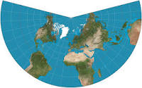
Azimuthal Projection
A map projection using a radial grid that is good for showing the poles of the Earth. It distorts shape and area.
Equal-area projection
A map projection that attempts to maintain the relative spatial science and the areas on the map
lambert projection
An example of an equal-area projection, often used for eronautical charts, portions of the State Plane Coordinate System, and many national and regional mapping systems
Conformal projections
Map projections that attempt to maintain the shape of polygons on the map
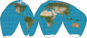
goode’s homolosine projection
Reference Maps
Maps that focus on locations of places like countries lakes and/or cities
Level of aggregation
The level at which you group things together for examination
Ecotone
The environmental transition zone between to biomes
Friction of distance
When the length of distance becomes a factor that inhibits the interaction between two points
Sinuous
To have a wavy pattern
Flow-line map
A map that uses lines of varying thickness to show the direction and volume of a particular geographic movement pattern
Spatial model
A model that is object-oriented with coverage and concerned with how the physical world works or looks.
Activity space
the location where regular behaviors occur
Homogeneous characteristic
A characteristic shared by a group of people
International date line
a boundary from which each calendar day starts
Royal Naval Observatory
Where the Prime meridian was fixed upon in Greenwich, England at 0 degrees longitude